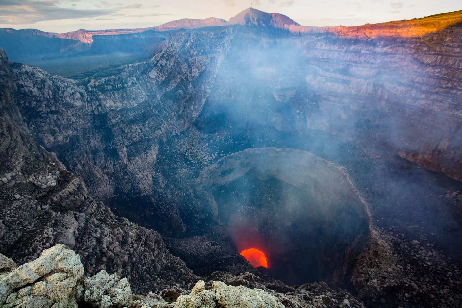
Twenty kilometers south of Managua, Masaya Volcano contains an active lava lake churning inside the Santiago crater. Visitors drive directly to the 635-meter summit to watch glowing magma and towering sulfur dioxide plumes.
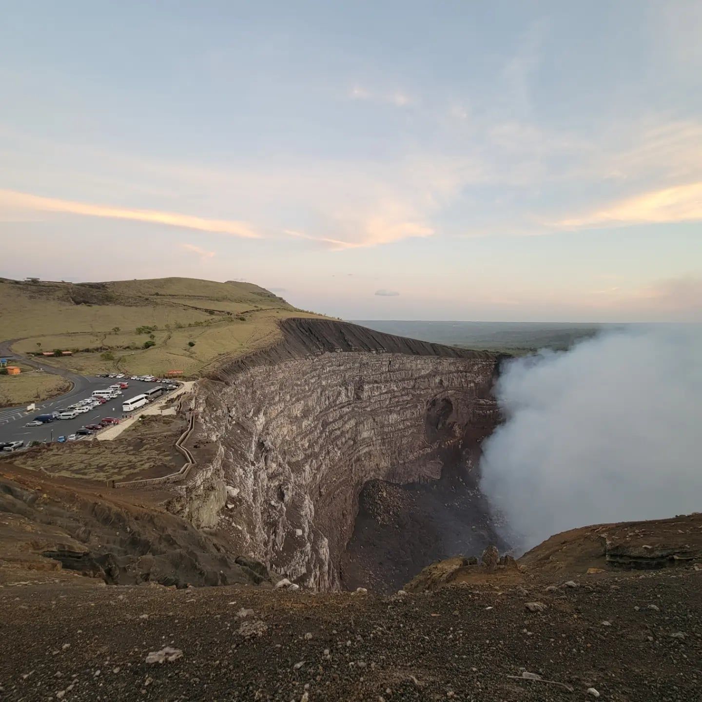
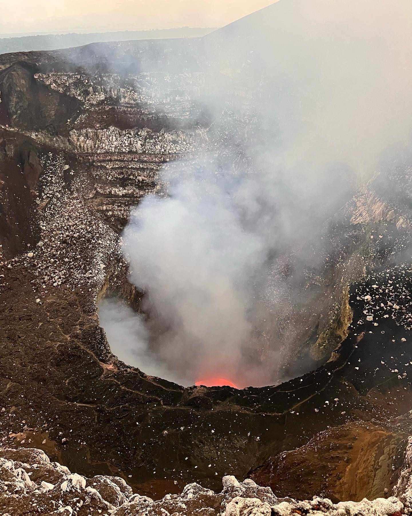
Toxic sulfur dioxide gas pours continuously from the Santiago crater at Masaya Volcano. Twenty kilometers south of Nicaragua's capital, this 54-square-kilometer national park centers around a 6-by-11.5-kilometer basaltic caldera. Magma bubbles just below the surface of the active vent, glowing bright red against the dark sky during evening visits. You can drive directly to the 635-meter summit, step out of your vehicle, and look straight down into the earth's core. The heat radiates upward against your face. A deep, mechanical roar echoes from the churning lava lake, sounding like a jet engine trapped underground.
Nicaragua designated this site as its first national park in 1979. The protected area encompasses 13 vents, vast fields of solidified black lava, and dry forest ecosystems that survive despite the acidic environment. Volcanologists use the site as an open-air laboratory, tracking micro-earthquakes and measuring gas emissions daily. Visitors share the summit with these researchers, standing on a paved viewing platform just meters from the sheer drop-off. The accessibility of the crater rim makes it a primary destination for geological study in Central America.
Toxic fumes dictate the rhythm of every visit. Park rangers enforce a strict 5-to-15-minute time limit at the rim to prevent respiratory distress. Heavy rain or sudden gas shifts frequently force immediate evacuations, sending crowds back to their vehicles. Cars parked at the summit must face downhill in designated lanes, ensuring a rapid exit if the volcano throws ash or volcanic bombs. Check the official park status before arriving, as landslides inside the crater occasionally block the gas vents and trigger sudden, unannounced park closures.
Beyond the main crater, the park offers a network of trails leading to inactive vents. The steep Masaya Trail climbs directly to the Mirador San Fernando, providing an unobstructed view into a dormant crater filled with dense vegetation. Hiking the four-kilometer Coyote or Comalito paths takes roughly two hours, routing visitors through dry forests and past steaming fumaroles. These trails require sturdy closed-toe shoes, as the terrain consists of loose volcanic gravel and jagged basaltic rock that easily cuts through thin soles.
Nine thousand years ago, massive basaltic eruptions laid the foundation for the Masaya volcanic complex. The current 6-by-11.5-kilometer caldera collapsed inward approximately 2,500 years ago following an 8-cubic-kilometer ignimbrite eruption. This violent geological collapse created the steep, 300-meter-high walls that enclose the modern crater system. Over the centuries, at least 19 major eruptions reshaped the interior landscape, building the distinct pyroclastic cones of Nindirí, San Fernando, and San Pedro. The magma chamber beneath the caldera remained highly active, pushing new vents to the surface.
Spanish colonizers documented the glowing crater in 1524, terrified by the continuous explosions and choking smoke. They named the site "La Boca del Infierno"—The Mouth of Hell. Four years later, a Mercedarian friar named Francisco de Bobadilla climbed the summit to exorcise the devil. He planted a massive wooden cross on the highest ridge overlooking the active vent. A replica of this cross still stands today at the end of a steep, 280-step concrete staircase. The Spanish repeatedly attempted to extract the glowing magma, lowering iron buckets into the abyss because they mistakenly believed the liquid rock was molten gold. The intense heat melted their equipment instantly.
The active Santiago crater formed recently, opening between 1850 and 1853. This specific vent quickly became the primary source of the volcano's continuous sulfur dioxide emissions, drawing magma from the shallow reservoir below. Throughout the 20th century, the volcano experienced cyclic periods of intense degassing and lava lake formation. Between 1965 and 1979, a prominent lava lake appeared in the Santiago crater, drawing international scientific attention. Researchers flocked to Nicaragua to study the unique convection currents visible in the magma. During this era, the government constructed the first paved road to the summit, fundamentally changing how humans interacted with the site. Instead of a grueling multi-day expedition, reaching the active vent became a brief drive, transforming Masaya into a major scientific and economic asset.
In 1979, the Nicaraguan government established the 54-square-kilometer area as the country's first national park to protect the unique geological formations and dry forest ecosystems. Two years later, a major gas emission phase in 1981 killed off surrounding vegetation, leaving the jagged basalt fields entirely barren. Explosive events continue to alter the landscape without warning. In April 2001, a sudden explosion ejected rocks up to 60 centimeters in diameter, damaging vehicles in the summit parking lot and injuring several visitors. More recently, in early 2024, significant landslides inside the Santiago crater buried the lava lake under tons of rock and debris. This blockage trapped pressurized gases, forcing authorities to close the park for months to monitor the risk of a larger explosion. Volcanologists now continuously monitor the 13 vents for seismic shifts, using tiltmeters and gas sensors to predict the next major event.
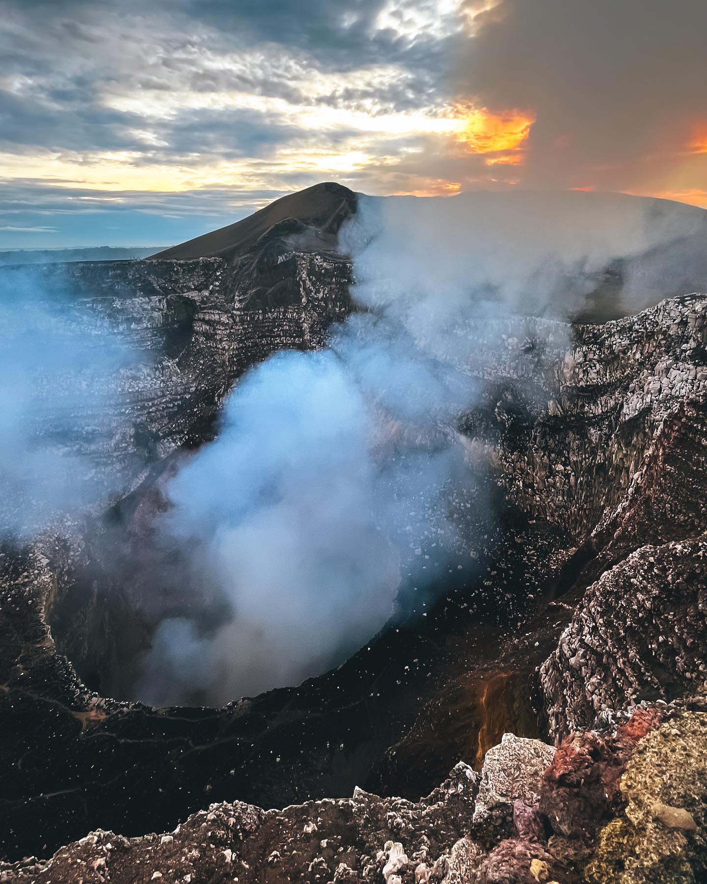
Steep caldera walls rising 300 meters high enclose the Masaya volcanic complex. The site sits directly on the Central America Volcanic Arc, driven by the Cocos tectonic plate subducting beneath the Caribbean plate. Inside the main 6-by-11.5-kilometer depression, four distinct pyroclastic cones—Masaya, Nindirí, San Fernando, and San Pedro—dominate the landscape. The active Santiago crater cuts directly into the Nindirí cone, measuring roughly 600 meters wide and dropping hundreds of meters to the magma surface. The sheer walls of the crater show distinct layers of historical lava flows, stacked like bands of black and red iron.
Solidified basaltic lava covers the caldera floor. These jagged, black rock fields stretch for kilometers, interrupted only by steaming fumaroles and sparse dry forest vegetation. The rock is highly vesicular, filled with tiny holes where volcanic gases escaped as the lava cooled. Beneath the surface, an extensive network of underground lava tubes snakes through the rock. The Tzinaconostoc Cave, a prominent collapsed lava tunnel, houses thousands of bats that emerge at dusk. Visitors can enter sections of these caves with certified guides, walking through perfectly cylindrical rock formations carved by flowing magma thousands of years ago.
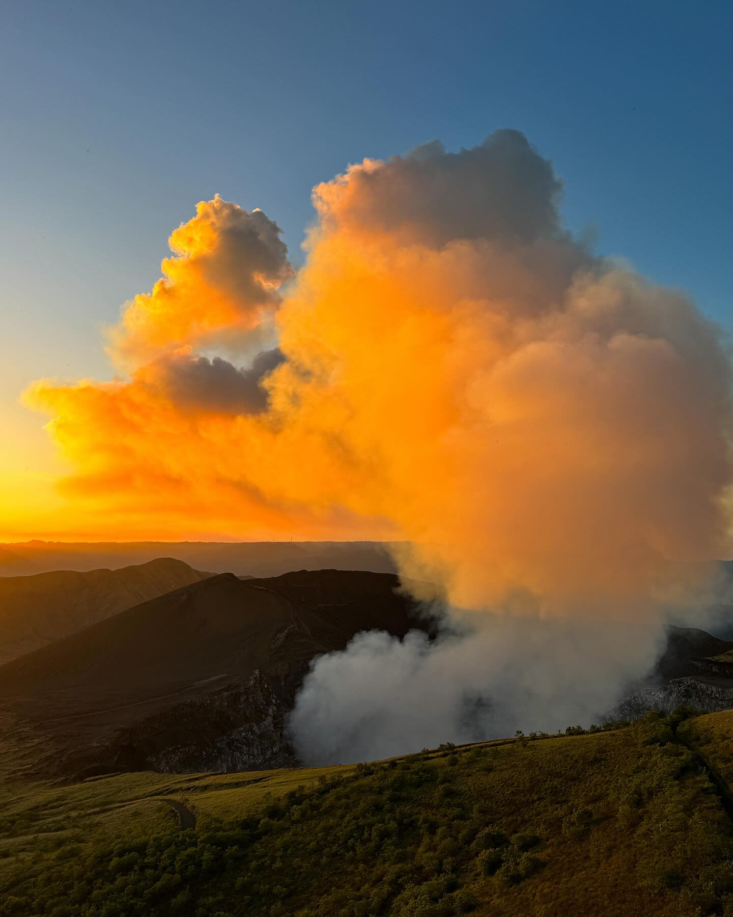
Thick white plumes of sulfur dioxide gas rise constantly from the Santiago vent. This acidic smoke drifts across the summit, heavily corroding metal guardrails, vehicles, and signs near the parking lot. The gas kills most plant life immediately downwind, creating a stark, lunar environment on the western rim. During the dry season, strong winds push these toxic clouds directly over the viewing platforms. Bring a respirator mask or a thick cloth to cover your mouth, as the sulfur quickly irritates the throat and lungs. Park infrastructure requires constant replacement due to the rapid oxidation caused by the volcanic atmosphere.
Just 15 minutes from the active crater lies the Laguna de Masaya. This massive volcanic lagoon sits at the eastern foot of the complex, filling a separate depression with deep, mineral-rich water. The contrast between the barren, smoking crater and the blue waters of the lagoon highlights the extreme geological diversity of the area. Runoff from the caldera walls feeds into the lake, carrying volcanic minerals that support a unique micro-ecosystem along the shoreline.
Indigenous Chorotega and Nawat peoples venerated the volcano long before Spanish galleons reached the Americas. They called the mountain Popogatepe, translating to "Boiling Mountain." Local tribes believed a powerful, fiery deity lived inside the churning lava, controlling the weather and the fertility of the surrounding soil. During periods of intense volcanic activity, severe drought, or failing crops, indigenous leaders performed human sacrifices. They threw individuals, often young children or captured enemies, into the active crater to appease the angry spirit and stop the eruptions. Archaeological surveys around the caldera rim have uncovered pottery fragments and ceremonial artifacts tied to these ancient rituals.
The arrival of Catholicism violently suppressed these indigenous practices. Spanish priests reframed the volcano as a literal gateway to hell, using the terrifying roar of the magma and the suffocating sulfur smoke as physical proof of demonic presence. The Bobadilla Cross, planted in 1528, functioned as a spiritual barrier to keep demons from escaping the crater and terrorizing the local settlements. This clash of belief systems remains a core part of Nicaraguan folklore, with local legends still referencing the spirits trapped beneath the lava. The cross itself has been replaced multiple times over the centuries due to rot and acidic corrosion, but its placement remains exactly where the friar originally stood.
Today, the national park operates as a massive educational hub for Nicaraguan citizens. The on-site Volcanology Museum documents both the indigenous mythology and the modern tectonic science of the region, featuring interactive models of the nested calderas. Local artisans from the nearby city of Masaya rely heavily on the park's steady stream of visitors. They sell handmade pottery, woven textiles, and wood carvings at the summit market near the entrance gate. The site provides a direct economic lifeline for hundreds of families in the surrounding Masaya department, linking the destructive power of the volcano to the financial survival of the local community.
Thousands of bats live inside the Tzinaconostoc Cave, an underground lava tunnel formed by ancient eruptions.
Spanish colonizers planted a massive wooden cross at the summit in 1528 to exorcise the devil from the crater.
Visitors can drive their vehicles straight to the edge of the active Santiago crater.
Early Spanish explorers repeatedly tried to lower iron buckets into the crater, mistaking the glowing magma for liquid gold.
Park rangers strictly limit summit visits to 5 to 15 minutes due to the continuous release of toxic sulfur dioxide gas.
All cars parked at the crater rim must face downhill to ensure a rapid evacuation during sudden explosive events.
A sudden explosion in April 2001 launched volcanic rocks up to 60 centimeters wide into the visitor parking lot.
You can view a bubbling lava lake inside the Santiago crater. The glowing red magma is most visible during night tours when the dark sky contrasts with the heat of the earth's core.
Daytime entry costs roughly $4 USD (C$150) for foreign visitors. The nighttime lava viewing session costs $10 USD for foreigners and $5 USD for Nicaraguan locals.
The park operates in two distinct shifts. Daytime access runs from 9:00 AM to 4:45 PM, while the nighttime viewing session operates from 5:00 PM to 8:00 PM.
The park enforces strict safety protocols to manage volcanic hazards. Visitors must park vehicles facing downhill for rapid evacuation and limit their time at the rim to 15 minutes to avoid toxic gas exposure.
Walking along the paved road from the main gate to the crater is prohibited. You must drive a vehicle, join an organized tour, or hire a local driver at the gate for about $5 USD.
The national park maintains several hiking routes, including the Coyote and Comalito trails. These four-kilometer paths take about two hours to complete and cross through dry forest ecosystems.
Friar Francisco de Bobadilla planted the original cross in 1528. He placed it at the summit to exorcise the devil from the active vent, which the Spanish called "The Mouth of Hell."
Children can enter the park, but prolonged exposure to the crater is dangerous for infants. The volcano continuously emits large plumes of sulfur dioxide gas that cause respiratory irritation.
Major landslides inside the Santiago crater buried the active lava lake and blocked the release of volcanic gases. Authorities closed the park for several months to monitor the risk of explosive activity.
The park features paved pathways, ramps at the visitor center, and a wheelchair-accessible viewing platform at the crater rim. The concrete safety wall is just over one meter high, which may partially block views from a seated position.
Browse verified tours with free cancellation and instant confirmation.
Find Tours